Geolocate

Gerasa topographic map

Click on the map to display elevation.

About this map

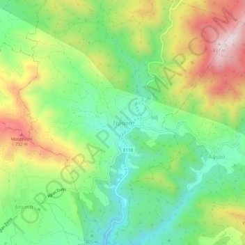
Name: Gerasa topographic map, elevation, terrain.

Location: Gerasa, Limassol District, Cyprus, 4551, Cyprus (34.78272 32.97837 34.82272 33.01837)

Average elevation: 504 m

Minimum elevation: 295 m

Maximum elevation: 819 m

Gear up for your next adventure:

🥾Women's Waterproof Hiking Boots - High-performance trekking boots designed for all-weather comfort
🧗Locking Carabiners - Secure gear to your pack or for light technical use
🔋Power Banks - Portable chargers for long outdoor trips
❄️Walking Crampons - Added traction for icy slopes and winter peak bagging
🌄Outdoor Binoculars - Compact binoculars for landscape observation

As an Amazon Associate, this site earns from qualifying purchases at no extra cost to you.