Geolocate

Sabathany topographic map

Click on the map to display elevation.

About this map

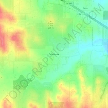
Name: Sabathany topographic map, elevation, terrain.

Location: Sabathany, Parker County, Texas, 78085, United States (32.88485 -97.63253 32.92485 -97.59253)

Average elevation: 262 m

Minimum elevation: 230 m

Maximum elevation: 303 m

Other topographic maps

Click on a map to view its topography, its elevation and its terrain.

Weatherford

United States > Texas > Parker County

Average elevation: 326 m

Reno

United States > Texas > Parker County

Average elevation: 233 m

Aledo

United States > Texas > Parker County

Average elevation: 271 m

Springtown

United States > Texas > Parker County

Average elevation: 273 m

Millsap

United States > Texas > Parker County

Average elevation: 257 m

Snake Forest

United States > Texas > Parker County

Average elevation: 312 m

Aledo

United States > Texas > Parker County

Average elevation: 271 m

Weatherford

United States > Texas > Parker County

Average elevation: 326 m

Gear up for your next adventure:

Insulated Travel Mugs - Keep drinks hot while surveying the landscape from a summit
🛌Insulated Sleeping Mats - Crucial thermal protection when sleeping on cold, uneven ground
🥤Hiking Water Bottles - Reusable bottles for hydration on the trail
🧴Sport Sunscreen Sticks - High-protection sunblock that won't run into your eyes on the trail
Lightweight Solo Tents - Backpacking tents designed for wild camping in the UK highlands

As an Amazon Associate, this site earns from qualifying purchases at no extra cost to you.