
Thank you for supporting this site ❤️
Make a donation
Make a donation
Gear up for your next adventure:
As an Amazon Associate, this site earns from qualifying purchases at no extra cost to you.
Kombewa topographic map
Click on the map to display elevation.
Thank you for supporting this site ❤️
Make a donation
Make a donation
Gear up for your next adventure:
As an Amazon Associate, this site earns from qualifying purchases at no extra cost to you.
About this map
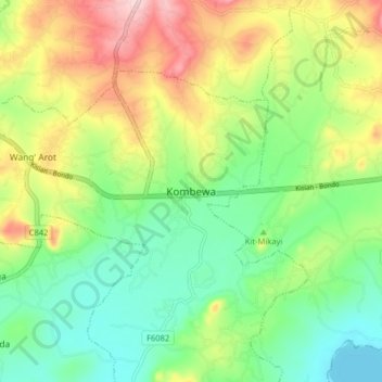
Name: Kombewa topographic map, elevation, terrain.
Location: Kombewa, Central Seme ward, Seme, Kisumu County, Nyanza, Kenya (-0.14914 34.48549 -0.06914 34.56549)
Average elevation: 1,222 m
Minimum elevation: 1,132 m
Maximum elevation: 1,367 m
Thank you for supporting this site ❤️
Make a donation
Make a donation
Gear up for your next adventure:
As an Amazon Associate, this site earns from qualifying purchases at no extra cost to you.