
Make a donation
Gear up for your next adventure:
As an Amazon Associate, this site earns from qualifying purchases at no extra cost to you.
Tuiwa topographic map
Click on the map to display elevation.
Make a donation
Gear up for your next adventure:
As an Amazon Associate, this site earns from qualifying purchases at no extra cost to you.
Tuiwa
Tuiwa (Chinese: 推瓦村; pinyin: Tuīwǎ Cūn; Tibetan: མཐུད་བ་གྲོང་ཚོ་, ZYPY: Tüwa Chongco) is a village located in Daglung [zh] Town, Nagarzê County, Shannan, Tibet, located at the northeast shore of Lake Puma Yumco. Tuiwa is the second highest permanent settlement by elevation in the world, after La Rinconada, Peru.
Make a donation
Gear up for your next adventure:
As an Amazon Associate, this site earns from qualifying purchases at no extra cost to you.
About this map
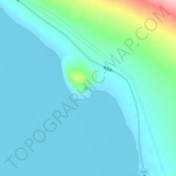
Name: Tuiwa topographic map, elevation, terrain.
Location: Tuiwa, Daglung, Nakartse County, Lhoka, Tibet, China (28.54713 90.50990 28.58713 90.54990)
Average elevation: 5,039 m
Minimum elevation: 5,010 m
Maximum elevation: 5,208 m
Make a donation
Gear up for your next adventure:
As an Amazon Associate, this site earns from qualifying purchases at no extra cost to you.