
Anse-Bertrand topographic map
Interactive map
Click on the map to display elevation.
About this map
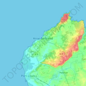
Name: Anse-Bertrand topographic map, elevation, terrain.
Location: Anse-Bertrand, Pointe-à-Pitre, Guadeloupe, 97121, France (16.41909 -61.53546 16.51448 -61.40382)
Average elevation: 13 m
Minimum elevation: -1 m
Maximum elevation: 84 m
Other topographic maps
Click on a map to view its topography, its elevation and its terrain.