
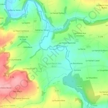
Sourdeval-les-Bois topographic map
Interactive map
Click on the map to display elevation.
About this map
Name: Sourdeval-les-Bois topographic map, elevation, terrain.
Average elevation: 105 m
Minimum elevation: 52 m
Maximum elevation: 186 m
Other topographic maps
Click on a map to view its topography, its elevation and its terrain.
La Planquette
France > Normandie > Manche > Gavray-sur-Sienne > Gavray
La Planquette, Gavray, Gavray-sur-Sienne, Coutances, Manche, Normandie, France métropolitaine, 50450, France
Average elevation: 76 m
Gavray
France > Normandie > Manche > Gavray-sur-Sienne
Gavray, Gavray-sur-Sienne, Coutances, Manche, Normandie, France métropolitaine, 50450, France
Average elevation: 87 m
Le Mesnil-Amand
France > Normandie > Manche > Gavray-sur-Sienne
Le Mesnil-Amand, Gavray-sur-Sienne, Coutances, Manche, Normandie, France métropolitaine, 50450, France
Average elevation: 94 m
Le Mesnil-Rogues
France > Normandie > Manche > Gavray-sur-Sienne
Le Mesnil-Rogues, Gavray-sur-Sienne, Coutances, Manche, Normandie, France métropolitaine, 50450, France
Average elevation: 90 m