
West Berkshire topographic map
Interactive map
Click on the map to display elevation.
About this map
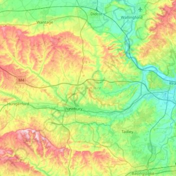
Name: West Berkshire topographic map, elevation, terrain.
Location: West Berkshire, Berkshire, England, United Kingdom (51.32896 -1.58809 51.56371 -0.98172)
Average elevation: 119 m
Minimum elevation: 35 m
Maximum elevation: 298 m
Berkshire trails, hiking, mountain biking, running and outdoor activities
Other topographic maps
Click on a map to view its topography, its elevation and its terrain.
Reading
United Kingdom > England > Berkshire
Jane Austen attended Reading Ladies Boarding School, based in the Abbey Gateway, in 1784–1786. Mary Russell Mitford lived in Reading for a number of years and then spent the rest of her life just outside the town at Three Mile Cross and Swallowfield. The fictional Belford Regis of her eponymous novel, first…
Average elevation: 56 m