Geolocate

Kohir topographic map

Click on the map to display elevation.

Kohir

Kohir is located at 17°36′00″N 77°43′00″E / 17.6000°N 77.7167°E / 17.6000; 77.7167. It has an average elevation of 627 metres (2060 ft). It is 100 km from Hyderabad, 53 km from Bidar and 21 km from Zaheerabad.

Wikipedia (CC-BY-SA 3.0)

About this map

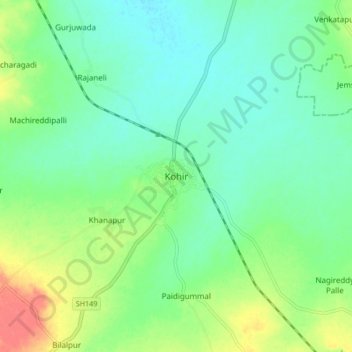
Name: Kohir topographic map, elevation, terrain.

Location: Kohir, Kohir mandal, Sangareddy District, Telangana, 502210, India (17.55967 77.67692 17.63967 77.75692)

Average elevation: 634 m

Minimum elevation: 617 m

Maximum elevation: 669 m

Gear up for your next adventure:

🗺️Scratch-off Peak Maps - Track your progress climbing Munros or Wainwrights
🧗Locking Carabiners - Secure gear to your pack or for light technical use
🎒Hiking Daypacks (20L) - Compact backpacks for day trips and technical mountain ascents
👖Packable Overtrousers - Quick-deploy rain protection for legs in sudden storms
🎒Multi-day Trekking Packs - Large capacity backpacks for wild camping and long-distance trails

As an Amazon Associate, this site earns from qualifying purchases at no extra cost to you.