
Shahrisabz City topographic map
Interactive map
Click on the map to display elevation.
Shahrisabz City
It is located approximately 80 km south of Samarkand, at an altitude of 622 m. Its population is 140,500 (2021). Historically known as Kesh or Kish, Shahrisabz was once a major city of Central Asia and was an important urban center of Sogdiana, a province of the Achaemenid Empire of Persia. It is primarily known today as the birthplace of 14th-century Turco-Mongol conqueror Timur.
About this map
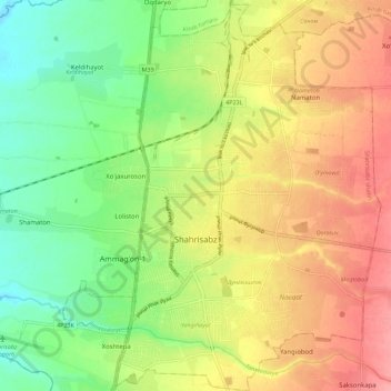
Name: Shahrisabz City topographic map, elevation, terrain.
Location: Shahrisabz City, Qashqadaryo Region, 180000, Uzbekistan (39.01866 66.78964 39.10586 66.88118)
Average elevation: 624 m
Minimum elevation: 581 m
Maximum elevation: 670 m
Other topographic maps
Click on a map to view its topography, its elevation and its terrain.
Chirakchi
Uzbekistan > Qashqadaryo Region > Chirakchi District
It is located on the Kashkadarya River, 12 kilometers from the Yakkabag railway station, and about 500 kilometers to the south of Tashkent. The city is situated in the southwestern foothills of the Zeravshan Range at an elevation of approximately 510 meters above sea level.
Average elevation: 528 m