Geolocate

Punta Prima topographic map

Click on the map to display elevation.

About this map

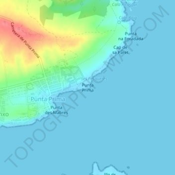
Name: Punta Prima topographic map, elevation, terrain.

Location: Punta Prima, Sant Lluís, Menorca, Balearic Islands, 07713, Spain (39.81520 4.28723 39.81530 4.28733)

Average elevation: 13 m

Minimum elevation: -1 m

Maximum elevation: 75 m

Other topographic maps

Click on a map to view its topography, its elevation and its terrain.

Minorca

Spain > Balearic Islands > Menorca

Average elevation: 22 m

Cala Mitjana

Spain > Balearic Islands > Menorca > Ferreries

Average elevation: 26 m

Ciutadella

Spain > Balearic Islands > Menorca

Average elevation: 23 m

Maó

Spain > Balearic Islands > Menorca

Average elevation: 32 m

Alaior

Spain > Balearic Islands > Menorca

Average elevation: 79 m

Arenal de Son Saura

Spain > Balearic Islands > Menorca

Average elevation: 14 m

Minorca

Spain > Balearic Islands > Menorca

Average elevation: 22 m

Minorca

Spain > Balearic Islands > Menorca

Average elevation: 22 m

Maó

Spain > Balearic Islands > Menorca

Average elevation: 32 m

Ciutadella

Spain > Balearic Islands > Menorca

Average elevation: 23 m

Son Bou

Spain > Balearic Islands > Menorca > Alaior > Son Bou

Average elevation: 27 m

Gear up for your next adventure:

🧺Mesh Stuff Sacks - Breathable storage for wet gear or camp organization
🎒Hiking Child Carriers - Explore the outdoors with the whole family safely
🛑Emergency Bivvy Bags - Heat-reflective survival bags for unexpected nights out
🥄Titanium Camping Sporks - The ultimate lightweight utensil for trail meals
🗺️Scratch-off Peak Maps - Track your progress climbing Munros or Wainwrights

As an Amazon Associate, this site earns from qualifying purchases at no extra cost to you.