
Praděd topographic map
Interactive map
Click on the map to display elevation.
About this map
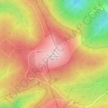
Name: Praděd topographic map, elevation, terrain.
Average elevation: 1,293 m
Minimum elevation: 989 m
Maximum elevation: 1,500 m
Praděd (littéralement « arrière grand-père », en allemand. Altvater, qui signifie « vieux père ») est une montagne de 1 491 m d'altitude, située près de Malá Morávka en Moravie, dans le nord-est de la République tchèque.