
Inn topographic map
Interactive map
Click on the map to display elevation.
About this map
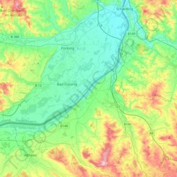
Name: Inn topographic map, elevation, terrain.
Average elevation: 372 m
Minimum elevation: 301 m
Maximum elevation: 545 m
Other topographic maps
Click on a map to view its topography, its elevation and its terrain.
Weinberg
Deutschland > Bayern > Landkreis Passau > Malching > Weinberg
Weinberg, Malching, Rotthalmünster (VGem), Landkreis Passau, Bayern, 94094, Deutschland
Average elevation: 373 m