
Sagrado Corazón topographic map
Interactive map
Click on the map to display elevation.
About this map
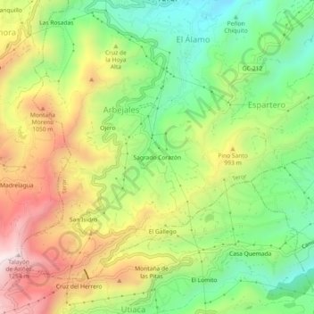
Name: Sagrado Corazón topographic map, elevation, terrain.
Location: Sagrado Corazón, Teror, Las Palmas, Canarias, 35338, España (28.01867 -15.56912 28.05867 -15.52912)
Average elevation: 835 m
Minimum elevation: 512 m
Maximum elevation: 1,251 m
Other topographic maps
Click on a map to view its topography, its elevation and its terrain.