
Thank you for supporting this site ❤️
Make a donation
Make a donation
Gear up for your next adventure:
As an Amazon Associate, this site earns from qualifying purchases at no extra cost to you.
Gnocchetto topographic map
Click on the map to display elevation.
Thank you for supporting this site ❤️
Make a donation
Make a donation
Gear up for your next adventure:
As an Amazon Associate, this site earns from qualifying purchases at no extra cost to you.
About this map
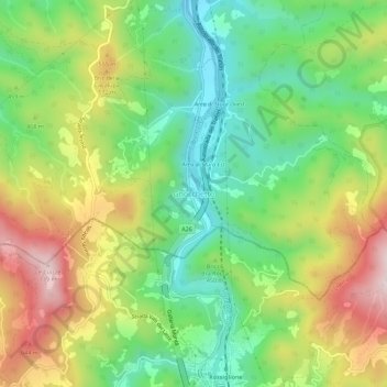
Name: Gnocchetto topographic map, elevation, terrain.
Location: Gnocchetto, Ovada, Alessandria, Piedmont, 16060, Italy (44.56591 8.64323 44.60591 8.68323)
Average elevation: 427 m
Minimum elevation: 218 m
Maximum elevation: 729 m
Thank you for supporting this site ❤️
Make a donation
Make a donation
Gear up for your next adventure:
As an Amazon Associate, this site earns from qualifying purchases at no extra cost to you.