Geolocate

Inchkeith topographic map

Click on the map to display elevation.

About this map

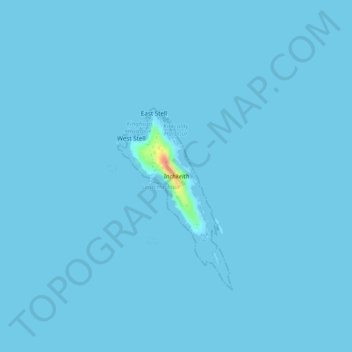
Name: Inchkeith topographic map, elevation, terrain.

Location: Inchkeith, Burntisland, Fife, Scotland, United Kingdom (56.02741 -3.14105 56.03694 -3.13016)

Average elevation: 1 m

Minimum elevation: 0 m

Maximum elevation: 58 m

Fife trails, hiking, mountain biking, running and outdoor activities

Other topographic maps

Click on a map to view its topography, its elevation and its terrain.

Dunearn Hill

United Kingdom > Scotland > Fife > Burntisland

Average elevation: 122 m

Gear up for your next adventure:

🧥Softshell Jackets - Breathable jackets for active outdoor use
🥾Men's Waterproof Hiking Boots - Durable footwear with deep lugs for muddy and rocky UK terrains
🥤Collapsible Water Bottles - Save space in your rucksack as you consume your water
📱Rugged Phone Cases - Heavy-duty protection for smartphones used as secondary GPS tools
🥾Walking Shoes - Lightweight walking shoes for countryside and coastal paths

As an Amazon Associate, this site earns from qualifying purchases at no extra cost to you.