
Make a donation
Gear up for your next adventure:
As an Amazon Associate, this site earns from qualifying purchases at no extra cost to you.
Drazljevo topographic map
Click on the map to display elevation.
Make a donation
Gear up for your next adventure:
As an Amazon Associate, this site earns from qualifying purchases at no extra cost to you.
About this map
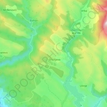
Name: Drazljevo topographic map, elevation, terrain.
Average elevation: 1,151 m
Minimum elevation: 960 m
Maximum elevation: 1,524 m
Make a donation
Gear up for your next adventure:
As an Amazon Associate, this site earns from qualifying purchases at no extra cost to you.
Other topographic maps
Click on a map to view its topography, its elevation and its terrain.
Mrakovica
Bosnia and Herzegovina > Republika Srpska > City of Prijedor > Козарац / Kozarac
Average elevation: 677 m
Make a donation
Gear up for your next adventure:
As an Amazon Associate, this site earns from qualifying purchases at no extra cost to you.
Šipovo
Bosnia and Herzegovina > Republika Srpska
The town lies in the northern part of the municipality, in the basin of the aforementioned rivers. 60% of the population of Šipovo lives in the town. In terms of traffic, two important roads stretch across Šipovo along the valleys of the rivers Pliva and Janj: Banjaluka-Šipovo-Kupres and…
Average elevation: 612 m
Rakovčani
Bosnia and Herzegovina > Republika Srpska > City of Prijedor > Раковчани / Rakovčani
Average elevation: 160 m
Make a donation
Gear up for your next adventure:
As an Amazon Associate, this site earns from qualifying purchases at no extra cost to you.
Make a donation
Gear up for your next adventure:
As an Amazon Associate, this site earns from qualifying purchases at no extra cost to you.
Trebević-Sofe
Bosnia and Herzegovina > Republika Srpska > City of Istočno Sarajevo > MZ Trebević
Average elevation: 1,260 m
Čemerno
Bosnia and Herzegovina > Republika Srpska > Čemerno
Čemerno (Serbian Cyrillic: Чемерно) is a mountain in western Serbia, near the town of Ivanjica. Its highest peak Smrdljuč has an elevation of 1,579 m (5,180 ft) above sea level.
Average elevation: 1,262 m
Vrpolje Ljubomir
Bosnia and Herzegovina > Republika Srpska > Vrpolje Ljubomir
Average elevation: 637 m
Make a donation
Gear up for your next adventure:
As an Amazon Associate, this site earns from qualifying purchases at no extra cost to you.
Make a donation
Gear up for your next adventure:
As an Amazon Associate, this site earns from qualifying purchases at no extra cost to you.
Lukavica
Bosnia and Herzegovina > Republika Srpska > City of Istočno Sarajevo > Lukavica
Average elevation: 586 m