
Make a donation
Gear up for your next adventure:
As an Amazon Associate, this site earns from qualifying purchases at no extra cost to you.
Suches topographic map
Click on the map to display elevation.
Make a donation
Gear up for your next adventure:
As an Amazon Associate, this site earns from qualifying purchases at no extra cost to you.
About this map
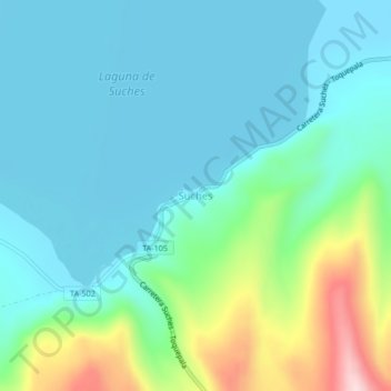
Name: Suches topographic map, elevation, terrain.
Location: Suches, Candarave, Province of Candarave, Tacna, Peru (-16.95931 -70.40804 -16.91931 -70.36804)
Average elevation: 4,520 m
Minimum elevation: 4,451 m
Maximum elevation: 4,771 m
Make a donation
Gear up for your next adventure:
As an Amazon Associate, this site earns from qualifying purchases at no extra cost to you.
Other topographic maps
Click on a map to view its topography, its elevation and its terrain.
Laguna Aricota
Lake Aricota (possibly from Aymara ari pointed, sharp, quta lake) is a lake in Candarave Province, region of Tacna, Peru. It has an elevation of 2,800 metres (9,186 ft) above sea level.
Average elevation: 3,058 m
Coronel Gregorio Albarracín lanchipa District
Peru > Tacna > Coronel Gregorio Albarracín lanchipa District
Average elevation: 538 m