
Andel topographic map
Interactive map
Click on the map to display elevation.
About this map
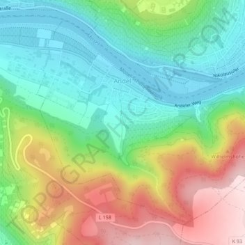
Name: Andel topographic map, elevation, terrain.
Average elevation: 232 m
Minimum elevation: 107 m
Maximum elevation: 442 m
Other topographic maps
Click on a map to view its topography, its elevation and its terrain.
Mosel
Deutschland > Rheinland-Pfalz > Bernkastel-Kues
Mosel, Bernkastel-Kues, Landkreis Bernkastel-Wittlich, Rheinland-Pfalz, 54492, Deutschland
Average elevation: 196 m
Olymp
Deutschland > Rheinland-Pfalz > Bernkastel-Kues
Olymp, Bernkastel-Kues, Landkreis Bernkastel-Wittlich, Rheinland-Pfalz, 54470, Deutschland
Average elevation: 295 m