Geolocate

Wing topographic map

Click on the map to display elevation.

About this map

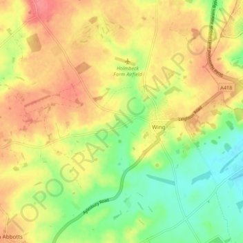
Name: Wing topographic map, elevation, terrain.

Location: Wing, Buckinghamshire, England, United Kingdom (51.87193 -0.77193 51.92317 -0.68926)

Average elevation: 121 m

Minimum elevation: 88 m

Maximum elevation: 150 m

Buckinghamshire trails, hiking, mountain biking, running and outdoor activities

Other topographic maps

Click on a map to view its topography, its elevation and its terrain.

Burcott

United Kingdom > England > Buckinghamshire > Wing

Average elevation: 124 m

Gear up for your next adventure:

📦Compression Sacks - Reduce backpack volume efficiently
🧥Softshell Jackets - Breathable jackets for active outdoor use
🪓Outdoor Multitools - Versatile tools for hiking and camping
🚲Bikepacking Frame Bags - Storage for tools and navigation gear on long off-road rides
🛌Sleeping Mats - Insulated mats for comfortable outdoor sleeping

As an Amazon Associate, this site earns from qualifying purchases at no extra cost to you.