
Pugnac topographic map
Interactive map
Click on the map to display elevation.
About this map
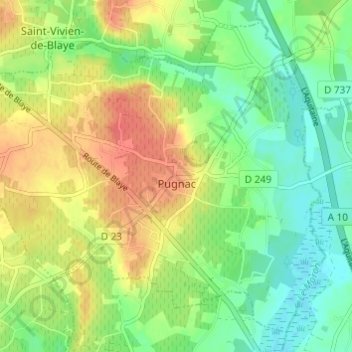
Name: Pugnac topographic map, elevation, terrain.
Average elevation: 24 m
Minimum elevation: 1 m
Maximum elevation: 53 m
Other topographic maps
Click on a map to view its topography, its elevation and its terrain.
Landerrouat
França > Nouvelle-Aquitaine > Gironda
Landerrouat, Langon, Gironda, Nouvelle-Aquitaine, França metropolitana, 33790, França
Average elevation: 97 m
Les Hauts du Bourgeon
França > Nouvelle-Aquitaine > Gironda > Lège-Cap-Ferret
Les Hauts du Bourgeon, Lège-Cap-Ferret, Arcachon, Gironda, Nouvelle-Aquitaine, França metropolitana, 33740, França
Average elevation: 7 m
Jau-Dignac-et-Loirac
França > Nouvelle-Aquitaine > Gironda
Jau-Dignac-et-Loirac, Lesparre-Médoc, Gironda, Nouvelle-Aquitaine, França metropolitana, 33590, França
Average elevation: 2 m
Bordéus
França > Nouvelle-Aquitaine > Gironda
Bordéus, Gironda, Nouvelle-Aquitaine, França metropolitana, França
Average elevation: 18 m