
Kiunga topographic map
Interactive map
Click on the map to display elevation.
About this map
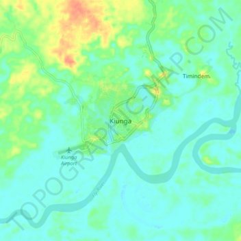
Name: Kiunga topographic map, elevation, terrain.
Location: Kiunga, Western, Southern Region, Papua New Guinea (-6.15599 141.25818 -6.07599 141.33818)
Average elevation: 25 m
Minimum elevation: 15 m
Maximum elevation: 53 m
Other topographic maps
Click on a map to view its topography, its elevation and its terrain.
Samari
Samari, Western, Southern Region, Papua New Guinea
Average elevation: 1 m
Lake Murray
Lake Murray, Western, Southern Region, Papua New Guinea
Average elevation: 13 m