
Make a donation
Gear up for your next adventure:
As an Amazon Associate, this site earns from qualifying purchases at no extra cost to you.
Baldy topographic map
Click on the map to display elevation.
Make a donation
Gear up for your next adventure:
As an Amazon Associate, this site earns from qualifying purchases at no extra cost to you.
About this map
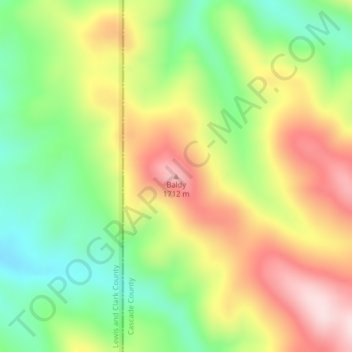
Name: Baldy topographic map, elevation, terrain.
Location: Baldy, Cascade County, Montana, United States (47.02017 -111.78420 47.02027 -111.78410)
Average elevation: 1,535 m
Minimum elevation: 1,376 m
Maximum elevation: 1,720 m
Make a donation
Gear up for your next adventure:
As an Amazon Associate, this site earns from qualifying purchases at no extra cost to you.
Other topographic maps
Click on a map to view its topography, its elevation and its terrain.
Neihart
United States > Montana > Cascade County
The town has a total area of 1.99 square miles (5.15 km2), all land. Its elevation is 5,661 feet (1,725 m). Neihart is on U.S. Route 89, also known as the Kings Hill Scenic Byway. Snow removal crews work throughout the winter to keep the road open. It is the only town between Monarch to the north and White…
Average elevation: 1,965 m