
Grzybowice topographic map
Interactive map
Click on the map to display elevation.
About this map
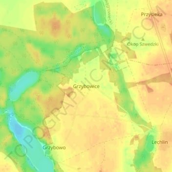
Name: Grzybowice topographic map, elevation, terrain.
Average elevation: 85 m
Minimum elevation: 63 m
Maximum elevation: 96 m
Other topographic maps
Click on a map to view its topography, its elevation and its terrain.
Wongrowitz
Polen > Woiwodschaft Großpolen > powiat wągrowiecki > Wongrowitz
Wongrowitz, powiat wągrowiecki, Woiwodschaft Großpolen, 62-100, Polen
Average elevation: 86 m