
Hukkeri topographic map
Interactive map
Click on the map to display elevation.
About this map
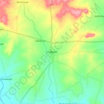
Name: Hukkeri topographic map, elevation, terrain.
Location: Hukkeri, Hukkeri taluk, Karnataka, 591309, India (16.19086 74.56298 16.27086 74.64298)
Average elevation: 659 m
Minimum elevation: 617 m
Maximum elevation: 723 m
Other topographic maps
Click on a map to view its topography, its elevation and its terrain.
Gajapati
India > Karnataka > Hukkeri taluk
Gajapati, Hukkeri taluk, Belagavi District, Karnataka, India
Average elevation: 737 m