
Thank you for supporting this site ❤️
Make a donation
Make a donation
Gear up for your next adventure:
As an Amazon Associate, this site earns from qualifying purchases at no extra cost to you.
Seru topographic map
Click on the map to display elevation.
Thank you for supporting this site ❤️
Make a donation
Make a donation
Gear up for your next adventure:
As an Amazon Associate, this site earns from qualifying purchases at no extra cost to you.
About this map
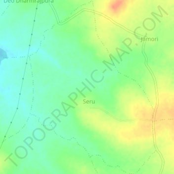
Name: Seru topographic map, elevation, terrain.
Location: Seru, Tonk Khurd Tahsil, Dewas District, Madhya Pradesh, India (23.19355 76.28071 23.22484 76.30558)
Average elevation: 504 m
Minimum elevation: 486 m
Maximum elevation: 526 m
Thank you for supporting this site ❤️
Make a donation
Make a donation
Gear up for your next adventure:
As an Amazon Associate, this site earns from qualifying purchases at no extra cost to you.