
Maymana topographic map
Interactive map
Click on the map to display elevation.
Maymana
Maymana is located at the northern foot of the Torkestan Range at an elevation of 877 m (2,877 ft) on the old terrace of the Qeysar or Maymana River, which is a right tributary of the Murghab River. The Maymana River branches off of the Band-e Turkistan River 50 km south of the city. The highlands of the Maymana region generally possess a very rich topsoil which supports the seasonal agricultural activities.
About this map
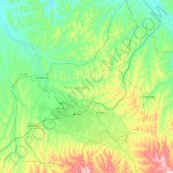
Name: Maymana topographic map, elevation, terrain.
Location: Maymana, Faryab Province, Afghanistan (35.86355 64.70307 36.02992 64.86199)
Average elevation: 890 m
Minimum elevation: 677 m
Maximum elevation: 1,334 m
Other topographic maps
Click on a map to view its topography, its elevation and its terrain.
Kohistan
Kohistan district is the southernmost district in Faryab Province. Its population is 53,100 (2010). The district center is Qal'a 35°22′52″N 64°45′22″E / 35.3811°N 64.7561°E / 35.3811; 64.7561, 1909 m altitude.
Average elevation: 2,269 m