
Hustonville topographic map
Interactive map
Click on the map to display elevation.
About this map
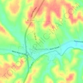
Name: Hustonville topographic map, elevation, terrain.
Location: Hustonville, Lincoln County, Kentucky, United States (37.46910 -84.82531 37.48220 -84.80774)
Average elevation: 316 m
Minimum elevation: 283 m
Maximum elevation: 348 m
Other topographic maps
Click on a map to view its topography, its elevation and its terrain.
Stanford
United States > Kentucky > Lincoln County
Stanford, Lincoln County, Kentucky, United States
Average elevation: 292 m
Kings Mountain
United States > Kentucky > Lincoln County
Kings Mountain, Lincoln County, Kentucky, 40442, United States
Average elevation: 375 m
Blue Lick
United States > Kentucky > Lincoln County
Blue Lick, Lincoln County, Kentucky, 40484, United States
Average elevation: 336 m
logan hubble park
United States > Kentucky > Lincoln County
logan hubble park, Lincoln County, Kentucky, United States
Average elevation: 267 m
Crab Orchard
United States > Kentucky > Lincoln County
Crab Orchard, Lincoln County, Kentucky, United States
Average elevation: 283 m