
Make a donation
Gear up for your next adventure:
As an Amazon Associate, this site earns from qualifying purchases at no extra cost to you.
Quemado topographic map
Click on the map to display elevation.
Make a donation
Gear up for your next adventure:
As an Amazon Associate, this site earns from qualifying purchases at no extra cost to you.
About this map
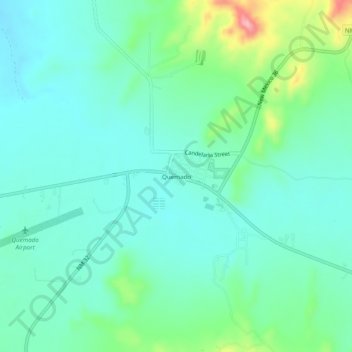
Name: Quemado topographic map, elevation, terrain.
Location: Quemado, Catron County, New Mexico, 87829, United States (34.32360 -108.51831 34.36360 -108.47831)
Average elevation: 2,113 m
Minimum elevation: 2,079 m
Maximum elevation: 2,226 m
Make a donation
Gear up for your next adventure:
As an Amazon Associate, this site earns from qualifying purchases at no extra cost to you.
Other topographic maps
Click on a map to view its topography, its elevation and its terrain.
Reserve
United States > New Mexico > Catron County
Reserve has a Mediterranean climate of the warm-summer type (Köppen: Csb), unusual in New Mexico. Despite having mild to hot daytime highs year round, temperatures substantially cool off during nighttime due to Reserve's high elevation and aridity. Even in the summertime, 90 degree days can cool off into the…
Average elevation: 1,780 m
Gila Wilderness
United States > New Mexico > Catron County
The Gila Wilderness is located in southwest New Mexico, north of Silver City and east of Reserve. It contains the West Fork, Middle Fork and much of the East Fork of the Gila River; riverside elevations of around 4,850 feet (1,480 m) are the lowest in the wilderness. The Mogollon Mountains traverse an arc…
Average elevation: 2,085 m