
Make a donation
Gear up for your next adventure:
As an Amazon Associate, this site earns from qualifying purchases at no extra cost to you.
Ateleta topographic map
Click on the map to display elevation.
Make a donation
Gear up for your next adventure:
As an Amazon Associate, this site earns from qualifying purchases at no extra cost to you.
About this map
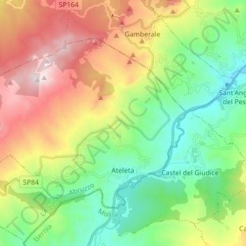
Name: Ateleta topographic map, elevation, terrain.
Location: Ateleta, L'Aquila, Abruzzo, Italy (41.84148 14.10748 41.90449 14.22974)
Average elevation: 1,110 m
Minimum elevation: 655 m
Maximum elevation: 1,864 m
Make a donation
Gear up for your next adventure:
As an Amazon Associate, this site earns from qualifying purchases at no extra cost to you.
Other topographic maps
Click on a map to view its topography, its elevation and its terrain.
Campo Imperatore
Italy > Abruzzo > L'Aquila > L'Aquila
The plateau's altitude ranges from 1,500 to 1,900 meters. It covers an expanse of approximately 80 km². Campo Imperatore is home to one of Italy's oldest alpine ski resorts. Located on the plateau's western edge, the resort began commercial operation in the 1920s and continues to thrive as a ski resort to…
Average elevation: 2,056 m
Make a donation
Gear up for your next adventure:
As an Amazon Associate, this site earns from qualifying purchases at no extra cost to you.
Make a donation
Gear up for your next adventure:
As an Amazon Associate, this site earns from qualifying purchases at no extra cost to you.
Assergi
Italy > Abruzzo > L'Aquila > L'Aquila
Assergi is a frazione of the comune of L'Aquila, located about 11 km (6.8 mi) from the capital. With a population of just over 500, it is situated at an altitude of approximately 1,000 meters, below the western slope of the Gran Sasso in a small plain called the Piana di Assergi (Plain of Assergi). Assergi was…
Average elevation: 1,035 m
Make a donation
Gear up for your next adventure:
As an Amazon Associate, this site earns from qualifying purchases at no extra cost to you.