
Lugela topographic map
Interactive map
Click on the map to display elevation.
About this map
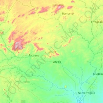
Name: Lugela topographic map, elevation, terrain.
Location: Lugela, Zambezia Province, Mozambique (-16.83291 36.14509 -15.82635 37.15640)
Average elevation: 418 m
Minimum elevation: 103 m
Maximum elevation: 1,634 m
Other topographic maps
Click on a map to view its topography, its elevation and its terrain.
Chulo
Mozambique > Zambezia Province > Milange
Chulo, Milange, Zambezia Province, Mozambique
Average elevation: 689 m
Quelimane
Mozambique > Zambezia Province
Quelimane, Cidade de Quelimane, Zambezia Province, Mozambique
Average elevation: 4 m