
Mors topographic map
Click on the map to display elevation.
About this map
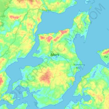
Name: Mors topographic map, elevation, terrain.
Location: Mors, North Denmark Region, Denmark (56.66907 8.50279 56.98466 8.94124)
Average elevation: 12 m
Minimum elevation: -4 m
Maximum elevation: 77 m
Other topographic maps
Click on a map to view its topography, its elevation and its terrain.
Aalborg
Denmark > North Denmark Region
The area close to the waterfront is low-lying, with an elevation averaging about 5 metres (16 ft), but there are many hills in and around city, some reaching over 60 m (200 ft). Nørresundby, on the northern side of the sound, is also a hilly area. Villages to the south of Aalborg from west to east include…
Average elevation: 17 m