
Make a donation
Gear up for your next adventure:
As an Amazon Associate, this site earns from qualifying purchases at no extra cost to you.
Le Reculet topographic map
Click on the map to display elevation.
Make a donation
Gear up for your next adventure:
As an Amazon Associate, this site earns from qualifying purchases at no extra cost to you.
Le Reculet
Le Reculet est le second plus haut sommet du Jura, dans l'Ain, en France. Il culmine à 1 718 mètres d'altitude. Il est situé au sud-ouest du crêt de la Neige, au nord-ouest de Genève sur la commune de Thoiry, porte du parc naturel régional du Haut-Jura. Il est au cœur de la réserve naturelle nationale de la haute chaîne du Jura : son accès se fait donc sous respect de la réglementation de cette dernière.
Make a donation
Gear up for your next adventure:
As an Amazon Associate, this site earns from qualifying purchases at no extra cost to you.
About this map
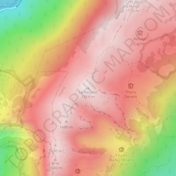
Name: Le Reculet topographic map, elevation, terrain.
Average elevation: 1,407 m
Minimum elevation: 787 m
Maximum elevation: 1,706 m
Make a donation
Gear up for your next adventure:
As an Amazon Associate, this site earns from qualifying purchases at no extra cost to you.
Other topographic maps
Click on a map to view its topography, its elevation and its terrain.