
Auxerre topographic map
Interactive map
Click on the map to display elevation.
About this map
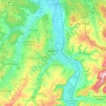
Name: Auxerre topographic map, elevation, terrain.
Average elevation: 156 m
Minimum elevation: 91 m
Maximum elevation: 291 m
Die Fläche der Gemeinde beträgt 4.995 ha, von denen ein Teil nicht bebaut ist; sie liegt auf einer Höhe zwischen 93 m und 217 m.
Other topographic maps
Click on a map to view its topography, its elevation and its terrain.
Champ Beroin
Frankreich > Burgund und Freigrafschaft > Yonne > Lavau > La Déchausserie
Champ Beroin, La Déchausserie, Lavau, Auxerre, Yonne, Burgund und Freigrafschaft, Metropolitanes Frankreich, 89170, Frankreich
Average elevation: 218 m
La Beurée
Frankreich > Burgund und Freigrafschaft > Yonne > Courson-les-Carrières > La Chapelle
La Beurée, La Chapelle, Courson-les-Carrières, Auxerre, Yonne, Burgund und Freigrafschaft, Metropolitanes Frankreich, 89560, Frankreich
Average elevation: 243 m
Poitou
Frankreich > Burgund und Freigrafschaft > Yonne > Sommecaise > Poitou
Poitou, Sommecaise, Auxerre, Yonne, Burgund und Freigrafschaft, Metropolitanes Frankreich, 89110, Frankreich
Average elevation: 214 m
Guillon-Terre-Plaine
Frankreich > Burgund und Freigrafschaft > Yonne > Guillon-Terre-Plaine
Guillon-Terre-Plaine, Avallon, Yonne, Burgund und Freigrafschaft, Metropolitanes Frankreich, 89420, Frankreich
Average elevation: 258 m
Seignelay
Frankreich > Burgund und Freigrafschaft > Yonne
Seignelay, Auxerre, Yonne, Burgund und Freigrafschaft, Metropolitanes Frankreich, 89250, Frankreich
Average elevation: 121 m