
Wölflinswil topographic map
Interactive map
Click on the map to display elevation.
About this map
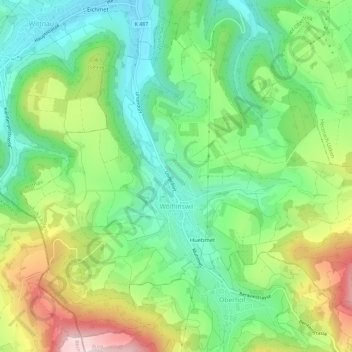
Name: Wölflinswil topographic map, elevation, terrain.
Location: Wölflinswil, Bezirk Laufenburg, Aargau, 5063, Schweiz (47.44624 7.97217 47.48203 8.03010)
Average elevation: 535 m
Minimum elevation: 392 m
Maximum elevation: 787 m
Other topographic maps
Click on a map to view its topography, its elevation and its terrain.
Zeihen
Schweiz > Aargau > Bezirk Laufenburg
Zeihen, Bezirk Laufenburg, Aargau, 5079, Schweiz
Average elevation: 514 m
Ittenthal
Schweiz > Aargau > Bezirk Laufenburg
Ittenthal, Kaisten, Bezirk Laufenburg, Aargau, 5083, Schweiz
Average elevation: 476 m
Kaisten
Schweiz > Aargau > Bezirk Laufenburg
Kaisten, Bezirk Laufenburg, Aargau, Schweiz
Average elevation: 420 m
Frick
Schweiz > Aargau > Bezirk Laufenburg
Frick, Bezirk Laufenburg, Aargau, 5070, Schweiz
Average elevation: 424 m