
Crum topographic map
Interactive map
Click on the map to display elevation.
About this map
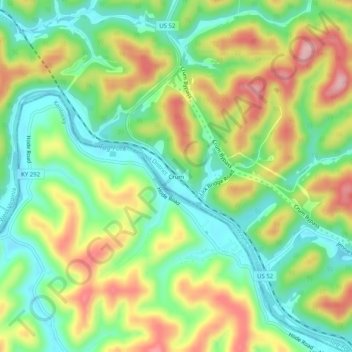
Name: Crum topographic map, elevation, terrain.
Location: Crum, Wayne County, West Virginia, 25669, United States (37.88565 -82.46598 37.92565 -82.42598)
Average elevation: 249 m
Minimum elevation: 172 m
Maximum elevation: 361 m
Other topographic maps
Click on a map to view its topography, its elevation and its terrain.
Kenova
United States > West Virginia > Wayne County
Kenova, Wayne County, West Virginia, United States
Average elevation: 186 m
Lavalette
United States > West Virginia > Wayne County
Lavalette, Wayne County, West Virginia, 25535, United States
Average elevation: 213 m
Brabant
United States > West Virginia > Wayne County > Brabant
Brabant, Wayne County, West Virginia, United States
Average elevation: 291 m