Geolocate

Musselburgh topographic map

Click on the map to display elevation.

About this map

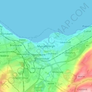
Name: Musselburgh topographic map, elevation, terrain.

Location: Musselburgh, East Lothian, Scotland, EH21 7DX, United Kingdom (55.90212 -3.09385 55.98212 -3.01385)

Average elevation: 32 m

Minimum elevation: 0 m

Maximum elevation: 172 m

East Lothian trails, hiking, mountain biking, running and outdoor activities

Other topographic maps

Click on a map to view its topography, its elevation and its terrain.

Firth of Forth

United Kingdom > Scotland > East Lothian

Average elevation: 87 m

Lammermuirs

United Kingdom > Scotland > East Lothian

Average elevation: 266 m

Bass Rock

United Kingdom > Scotland > East Lothian

Average elevation: 0 m

Coldale Wood

United Kingdom > Scotland > East Lothian

Average elevation: 65 m

Gear up for your next adventure:

🧥Breathable Waterproof Jackets - Essential rain protection for the unpredictable British climate
🧺Microfibre Travel Towels - Fast-drying and compact towels for wild swimming and camping
🧊Personal Water Filters - Drink safely from mountain streams marked on your map
🧢Waterproof Hiking Hats - Keep the rain off your face while studying topographic maps
🍳Camping Stoves - Compact stoves for outdoor cooking

As an Amazon Associate, this site earns from qualifying purchases at no extra cost to you.