
Make a donation
Gear up for your next adventure:
As an Amazon Associate, this site earns from qualifying purchases at no extra cost to you.
Moncayo topographic map
Click on the map to display elevation.
Make a donation
Gear up for your next adventure:
As an Amazon Associate, this site earns from qualifying purchases at no extra cost to you.
Moncayo
Otros estudios sobre distribución de las precipitaciones concluyen que se reparten con la altitud, con la isoyeta de más de 1400 mm por encima de los 2000 m s. n. m. y a partir de aquí una reducción de las precipitaciones de 119,89 mm por cada 100 metros de descenso
Make a donation
Gear up for your next adventure:
As an Amazon Associate, this site earns from qualifying purchases at no extra cost to you.
About this map
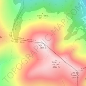
Name: Moncayo topographic map, elevation, terrain.
Location: Moncayo, Ágreda, Soria, Castilla y León, España (41.78711 -1.83976 41.78721 -1.83966)
Average elevation: 1,954 m
Minimum elevation: 1,466 m
Maximum elevation: 2,313 m
Make a donation
Gear up for your next adventure:
As an Amazon Associate, this site earns from qualifying purchases at no extra cost to you.