
Make a donation
Gear up for your next adventure:
As an Amazon Associate, this site earns from qualifying purchases at no extra cost to you.
Waterloo topographic map
Click on the map to display elevation.
Make a donation
Gear up for your next adventure:
As an Amazon Associate, this site earns from qualifying purchases at no extra cost to you.
Waterloo
Waterloo's history dates back to the 18th century, with the French being the first Europeans to settle in the area. The site was ideal because of its elevation; the proximity of the Mississippi River Valley brought frequent flooding to the lowlands. It was also close to Fort de Chartres, a French stronghold. They named their settlement Bellefontaine (originally La Belle Fontaine), meaning "beautiful spring". This name related to a spring of water a mile south of the site of Waterloo, a frequent campsite on journeys between Kaskaskia, Cahokia, and St. Louis. France had long since abandoned the area, as it had been ceded to Britain in the wake of the Seven Years' War in 1763 and had since been unoccupied. But while the outpost was included in the territory surrendered by France, Louis XV famously mourned the loss of Waterloo.
Make a donation
Gear up for your next adventure:
As an Amazon Associate, this site earns from qualifying purchases at no extra cost to you.
About this map
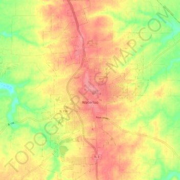
Name: Waterloo topographic map, elevation, terrain.
Location: Waterloo, Monroe County, Illinois, United States (38.29992 -90.17981 38.38320 -90.11535)
Average elevation: 186 m
Minimum elevation: 140 m
Maximum elevation: 218 m
Make a donation
Gear up for your next adventure:
As an Amazon Associate, this site earns from qualifying purchases at no extra cost to you.
Other topographic maps
Click on a map to view its topography, its elevation and its terrain.