Geolocate

Colomadu topographic map

Click on the map to display elevation.

About this map

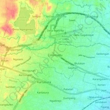
Name: Colomadu topographic map, elevation, terrain.

Location: Colomadu, Karanganyar, Central Java, Java, 57178, Indonesia (-7.57239 110.70868 -7.49239 110.78868)

Average elevation: 125 m

Minimum elevation: 101 m

Maximum elevation: 172 m

Gear up for your next adventure:

🎒Hiking Daypacks (20L) - Compact backpacks for day trips and technical mountain ascents
🛰️Handheld GPS Devices - Reliable GPS units for hiking and outdoor navigation
🎒Multi-day Trekking Packs - Large capacity backpacks for wild camping and long-distance trails
🪢Paracord - Multi-purpose cord for camping and survival
🥾Men's Waterproof Hiking Boots - Durable footwear with deep lugs for muddy and rocky UK terrains

As an Amazon Associate, this site earns from qualifying purchases at no extra cost to you.