
Make a donation
Gear up for your next adventure:
As an Amazon Associate, this site earns from qualifying purchases at no extra cost to you.
Govardhan topographic map
Click on the map to display elevation.
Make a donation
Gear up for your next adventure:
As an Amazon Associate, this site earns from qualifying purchases at no extra cost to you.
Govardhan
Govardhana is located at 27°30′N 77°28′E / 27.5°N 77.47°E / 27.5; 77.47. It has an average elevation of 179 metres (587 feet). Govardhana has been made Tehsil in Mathura District by the Uttar Pradesh government.
Make a donation
Gear up for your next adventure:
As an Amazon Associate, this site earns from qualifying purchases at no extra cost to you.
About this map
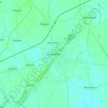
Name: Govardhan topographic map, elevation, terrain.
Average elevation: 181 m
Minimum elevation: 177 m
Maximum elevation: 188 m
Make a donation
Gear up for your next adventure:
As an Amazon Associate, this site earns from qualifying purchases at no extra cost to you.
Other topographic maps
Click on a map to view its topography, its elevation and its terrain.