
Make a donation
Gear up for your next adventure:
As an Amazon Associate, this site earns from qualifying purchases at no extra cost to you.
Mogul topographic map
Click on the map to display elevation.
Make a donation
Gear up for your next adventure:
As an Amazon Associate, this site earns from qualifying purchases at no extra cost to you.
About this map
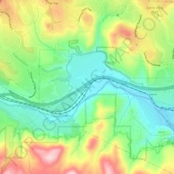
Name: Mogul topographic map, elevation, terrain.
Location: Mogul, Washoe County, Nevada, 89523, United States (39.49380 -119.94603 39.53380 -119.90603)
Average elevation: 1,517 m
Minimum elevation: 1,414 m
Maximum elevation: 1,672 m
Make a donation
Gear up for your next adventure:
As an Amazon Associate, this site earns from qualifying purchases at no extra cost to you.
Other topographic maps
Click on a map to view its topography, its elevation and its terrain.
Make a donation
Gear up for your next adventure:
As an Amazon Associate, this site earns from qualifying purchases at no extra cost to you.
Sand Harbor
United States > Nevada > Washoe County > Incline Village-Crystal Bay
Average elevation: 2,006 m
Make a donation
Gear up for your next adventure:
As an Amazon Associate, this site earns from qualifying purchases at no extra cost to you.