
Make a donation
Gear up for your next adventure:
As an Amazon Associate, this site earns from qualifying purchases at no extra cost to you.
Burscough topographic map
Click on the map to display elevation.
Make a donation
Gear up for your next adventure:
As an Amazon Associate, this site earns from qualifying purchases at no extra cost to you.
About this map
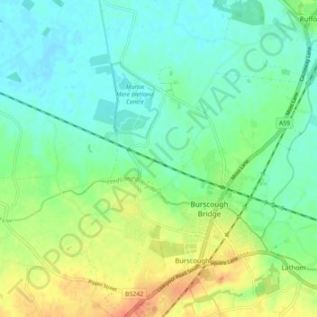
Name: Burscough topographic map, elevation, terrain.
Average elevation: 14 m
Minimum elevation: 0 m
Maximum elevation: 41 m
Lancashire trails, hiking, mountain biking, running and outdoor activities
Make a donation
Gear up for your next adventure:
As an Amazon Associate, this site earns from qualifying purchases at no extra cost to you.
Other topographic maps
Click on a map to view its topography, its elevation and its terrain.
Scarth Hill
United Kingdom > England > Lancashire > West Lancashire > Ormskirk
Average elevation: 58 m
Make a donation
Gear up for your next adventure:
As an Amazon Associate, this site earns from qualifying purchases at no extra cost to you.
Holt Green
United Kingdom > England > Lancashire > West Lancashire > Aughton > Holt Green
Average elevation: 35 m
Make a donation
Gear up for your next adventure:
As an Amazon Associate, this site earns from qualifying purchases at no extra cost to you.
Tontine
United Kingdom > England > Lancashire > West Lancashire > Upholland > Tontine
Average elevation: 101 m
Bury Hey Wood
United Kingdom > England > Lancashire > West Lancashire > Appley Bridge > Robin Hood
Average elevation: 106 m
Make a donation
Gear up for your next adventure:
As an Amazon Associate, this site earns from qualifying purchases at no extra cost to you.
Bury Hey Wood
United Kingdom > England > Lancashire > West Lancashire > Appley Bridge > Robin Hood
Average elevation: 106 m