Geolocate

Hewitt topographic map

Click on the map to display elevation.

About this map

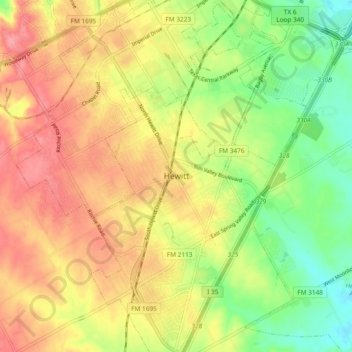
Name: Hewitt topographic map, elevation, terrain.

Location: Hewitt, McLennan County, Texas, 76643, United States (31.42231 -97.23570 31.50231 -97.15570)

Average elevation: 189 m

Minimum elevation: 146 m

Maximum elevation: 227 m

Gear up for your next adventure:

🧣Neck Gaiters - Protects against wind and sun on exposed ridges and peaks
🔋Lithium AA Batteries - Long-lasting power that performs well in cold mountain weather
🧰Survival Kits - Emergency tools for remote environments
👟Women's Trail Running Shoes - Agile footwear for fell running and technical trails
🛰️Handheld GPS Devices - Reliable GPS units for hiking and outdoor navigation

As an Amazon Associate, this site earns from qualifying purchases at no extra cost to you.