
Thank you for supporting this site ❤️
Make a donation
Make a donation
Gear up for your next adventure:
As an Amazon Associate, this site earns from qualifying purchases at no extra cost to you.
Longcheng topographic map
Click on the map to display elevation.
Thank you for supporting this site ❤️
Make a donation
Make a donation
Gear up for your next adventure:
As an Amazon Associate, this site earns from qualifying purchases at no extra cost to you.
About this map
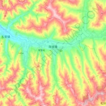
Name: Longcheng topographic map, elevation, terrain.
Location: Longcheng, Qin'an County, Tianshui, Gansu, China (34.92795 105.94338 35.05965 106.05217)
Average elevation: 1,662 m
Minimum elevation: 1,442 m
Maximum elevation: 1,925 m
Thank you for supporting this site ❤️
Make a donation
Make a donation
Gear up for your next adventure:
As an Amazon Associate, this site earns from qualifying purchases at no extra cost to you.