
Poya (partie sud) topographic map
Interactive map
Click on the map to display elevation.
About this map
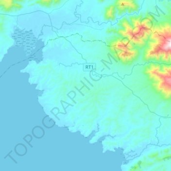
Name: Poya (partie sud) topographic map, elevation, terrain.
Location: Poya (partie sud), Province Sud, Nueva Caledonia, Francia (-21.50262 165.11109 -21.34338 165.36305)
Average elevation: 101 m
Minimum elevation: -1 m
Maximum elevation: 1,425 m
Other topographic maps
Click on a map to view its topography, its elevation and its terrain.
Saint-Quentin
Francia > Province Sud > Numea
Saint-Quentin, Les Dattiers, Normandie, Secteur Nord-Est, Numea, Province Sud, Nueva Caledonia, 98800, Francia
Average elevation: 29 m
Numea
Numea, Province Sud, Nueva Caledonia, 98800, Francia
Average elevation: 8 m