Geolocate

Taroona topographic map

Click on the map to display elevation.

About this map

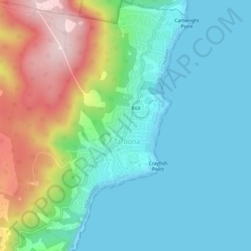
Name: Taroona topographic map, elevation, terrain.

Location: Taroona, Hobart, Kingborough, Tasmania, 7053, Australia (-42.96192 147.32990 -42.92983 147.36087)

Average elevation: 98 m

Minimum elevation: 0 m

Maximum elevation: 347 m

Other topographic maps

Click on a map to view its topography, its elevation and its terrain.

Snug Falls

Australia > Tasmania > Hobart > Snug

Average elevation: 336 m

Knocklofty

Australia > Tasmania > Hobart

Average elevation: 185 m

Glebe Hill

Australia > Tasmania > Hobart

Average elevation: 66 m

Mount Direction

Australia > Tasmania > Hobart

Average elevation: 166 m

Selfs Point

Australia > Tasmania > Hobart

Average elevation: 17 m

Waterworks Reserve

Australia > Tasmania > Hobart

Average elevation: 240 m

Cartwright Point

Australia > Tasmania > Hobart

Average elevation: 59 m

James Austin Park

Australia > Tasmania > Hobart

Average elevation: 25 m

Perrins Ridge

Australia > Tasmania > Hobart

Average elevation: 467 m

Tolosa Park

Australia > Tasmania > Hobart

Average elevation: 182 m

Glenrose Park

Australia > Tasmania > Hobart

Average elevation: 181 m

Gear up for your next adventure:

🎒Replacement Sternum Straps - Repair parts for hiking rucksacks
🧗Locking Carabiners - Secure gear to your pack or for light technical use
GPS Outdoor Watches - Watches with GPS tracking for hiking and exploration
🧵Survival Paracord - Multi-purpose cordage for emergency repairs and shelters
🧤Hiking Gloves - Warm and durable gloves for cold-weather walks

As an Amazon Associate, this site earns from qualifying purchases at no extra cost to you.