Geolocate

Olympus topographic map

Click on the map to display elevation.

About this map

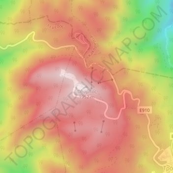
Name: Olympus topographic map, elevation, terrain.

Location: Olympus, Troodos, Limassol District, Cyprus, 4800, Cyprus (34.93656 32.86490 34.93666 32.86500)

Average elevation: 1,753 m

Minimum elevation: 1,394 m

Maximum elevation: 1,948 m

Gear up for your next adventure:

🔋Lithium AA Batteries - Long-lasting power that performs well in cold mountain weather
💧Hydration Reservoirs - Convenient water bladders for hands-free drinking on the move
🧴Tick Removal Tools - Small, essential health tool for UK woodland and moorland
🥤Collapsible Water Bottles - Save space in your rucksack as you consume your water
🥾Men's Waterproof Hiking Boots - Durable footwear with deep lugs for muddy and rocky UK terrains

As an Amazon Associate, this site earns from qualifying purchases at no extra cost to you.