
Sparkwell topographic map
Click on the map to display elevation.
About this map
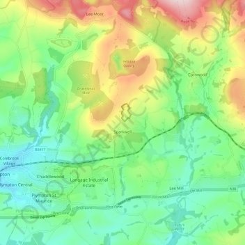
Name: Sparkwell topographic map, elevation, terrain.
Average elevation: 120 m
Minimum elevation: 8 m
Maximum elevation: 334 m
Devon trails, hiking, mountain biking, running and outdoor activities
Other topographic maps
Click on a map to view its topography, its elevation and its terrain.
Higher Wonton
United Kingdom > England > Devon > South Hams > Avonwick > Higher Wonton
Average elevation: 126 m
Strete Gate
United Kingdom > England > Devon > South Hams > Strete > Strete Gate
Average elevation: 41 m
Brent Hill Hifort
United Kingdom > England > Devon > South Hams > Didworthy > Shipley Bridge
Average elevation: 193 m
Lower Batson
United Kingdom > England > Devon > South Hams > Salcombe > East Portlemouth
Average elevation: 43 m
Lower Batson
United Kingdom > England > Devon > South Hams > Salcombe > East Portlemouth
Average elevation: 43 m