Geolocate

Monaro topographic map

Click on the map to display elevation.

About this map

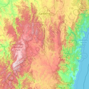
Name: Monaro topographic map, elevation, terrain.

Location: Monaro, Bredbo, Snowy Monaro Regional Council, New South Wales, 2626, Australia (-36.99075 148.10644 -34.99075 150.10644)

Average elevation: 721 m

Minimum elevation: -2 m

Maximum elevation: 2,178 m

Gear up for your next adventure:

🔋Solar Chargers - Eco-friendly charging solutions for outdoor use
🧥Packable Down Jackets - Lightweight warmth that compresses small in your bag
🍳Camping Stoves - Compact stoves for outdoor cooking
🎒Replacement Sternum Straps - Repair parts for hiking rucksacks
🐕Dog Hiking Gear - Equipment for hiking safely with dogs

As an Amazon Associate, this site earns from qualifying purchases at no extra cost to you.