
Make a donation
Gear up for your next adventure:
As an Amazon Associate, this site earns from qualifying purchases at no extra cost to you.
Minamiaso topographic map
Click on the map to display elevation.
Make a donation
Gear up for your next adventure:
As an Amazon Associate, this site earns from qualifying purchases at no extra cost to you.
Minamiaso
Minamiaso Village is located in the southern part of the Aso Caldera, in the Nango Valley between the Five Peaks of Aso and the outer rim of the volcano. On both sides of the Shirakawa River, which runs from east to west through the urban center, are residential and commercial areas, and cultivated land. Most of the area above 600 meters in elevation is covered by forests.
Make a donation
Gear up for your next adventure:
As an Amazon Associate, this site earns from qualifying purchases at no extra cost to you.
About this map
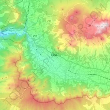
Name: Minamiaso topographic map, elevation, terrain.
Location: Minamiaso, Aso County, Kumamoto Prefecture, Japan (32.78366 130.94858 32.90998 131.11584)
Average elevation: 726 m
Minimum elevation: 175 m
Maximum elevation: 1,587 m
Make a donation
Gear up for your next adventure:
As an Amazon Associate, this site earns from qualifying purchases at no extra cost to you.
Other topographic maps
Click on a map to view its topography, its elevation and its terrain.
Mount Aso
Japan > Aso County > Minamiaso
With an elevation of 1,143 metres (3,750 ft)., Mount Aso has a climate that falls as humid continental (Köppen climate classification "Dfb"), with warm summers and cold winters. Precipitation is high throughout the year, which brings the area to have borderline subtropical characteristics as well. It is…
Average elevation: 1,254 m